
Mt Hight Hike
Mt. Hight
Details
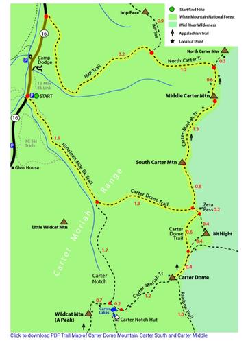
Join us on this 8.8-mile out-and-back trail near Pinkham Notch, New Hampshire. Generally considered a challenging route with an elevation gain of 3200 feet, it takes an average of 6-7 hours to complete.
Mt. Hight's summit provides hikers with spectacular views in all directions, including a great look across the notch at the lofty Northern Presidentials, views north and south along the Carter-Moriah Range (which Mt. Hight is a part of), and an expansive vista over the Wild River Wilderness.
Microspikes and possibly snowshoes will be needed. An update on trail conditions will be sent out a few days before the hike.
Hikers are invited to an après hike potluck/get-together after the hike at my house in Sugar Hill NH.
If you have questions about winter hiking or gear needed, please email me. Hikers can stay at my house on Friday and/or Saturday nights if desired.
Directions
The parking area is at the 19 Mile Brook Parking area located on the east side of the road, 6.8 miles south of Rt. 16's eastern junction with Rt. 2 and 12.8 miles north of its northern junction with Rt. 16A. Hikers can also carpool over to the trailhead from my house in Sugar Hill, NH. Email me for directions to the house if needed.
About this event
Join us on this 8.8-mile out-and-back trail near Pinkham Notch, New Hampshire. Generally considered a challenging route with an elevation gain of 3200 feet, it takes an average of 6-7 hours to complete.
Mt. Hight's summit provides hikers with spectacular views in all directions, including a great look across the notch at the lofty Northern Presidentials, views north and south along the Carter-Moriah Range (which Mt. Hight is a part of), and an expansive vista over the Wild River Wilderness.
Microspikes and possibly snowshoes will be needed. An update on trail conditions will be sent out a few days before the hike.
Hikers are invited to an après hike potluck/get-together after the hike at my house in Sugar Hill NH.
If you have questions about winter hiking or gear needed, please email me. Hikers can stay at my house on Friday and/or Saturday nights if desired.
Directions to the trailhead
Get directionsThe parking area is at the 19 Mile Brook Parking area located on the east side of the road, 6.8 miles south of Rt. 16's eastern junction with Rt. 2 and 12.8 miles north of its northern junction with Rt. 16A. Hikers can also carpool over to the trailhead from my house in Sugar Hill, NH. Email me for directions to the house if needed.
Who's going (5)



Questions about this event?
Reach out to the host, Bobcat, for route details, carpooling, or what to bring.
Email the hostYou can also ask in the event discussion below.
Event discussion
Log in to join the conversation.