
Deboullie Mtn - hike to fire tower
Hike up an unmaintained trail to the fire tower on Deboullie Mtn. Trail used by snowmobiles in winter.
Deboullie Mtn - hike to fire tower
Hike up an unmaintained trail to the fire tower on Deboullie Mtn. Trail used by snowmobiles in winter.
Details
This hike is WAY up in northern Maine near Fort Kent. So far north that nobody is going to want to drive up with such short notice, or even with several weeks notice! LOL :) But I'll post the hike anyway. :) For anyone who is actually considering this, I do believe Ft. Kent has only one motel.
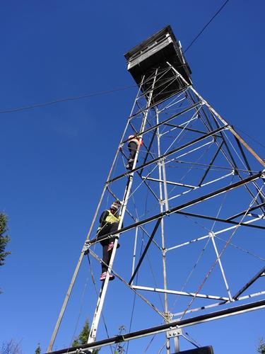
Deboullie Mtn is located in the Deboullie Public Land in a very remote, rugged and scenic area of northern Maine. There is a fire tower at the top with ladder access. Elevation is around 1,980 feet.
My route up the mountain is not on one of the usual maintained hiking trails. My route will be going up the back (boring) side of the mountain. In the winter people go up the mountain on snowmobiles, and I believe many years ago people were able to drive Jeeps up the mountain.
On Labor Day weekend I drove to this area to scout for the trail and I eventually found what I do believe is the trail. The trail is shown on old topo maps and what I found seems to fit that area. I also found cut trees in the trail that look older than the more recent logging activity. Since this is not a maintained hiking trail, expect unknown conditions. (Mud, water, downed trees)
The hike will be about 1.75 miles each way. Elevation gain is around 680 feet.
Although I'm fairly confident I found the trail, there is a chance I could be wrong. In that case we'll just go around to the south side and hike up the maintained trail. 2 miles each way with an elevation gain of around 850 feet in the last 0.6 miles.
After the hike we can drive 16 miles around to the south side of Deboullie where there are many scenic views from the ponds. From there we'll make our way to Portage 28 miles to the southeast, where we'll hit paved roads again.
Fall foliage is peak in this area, and views should be excellent.
The hike itself is not a full day hike, but the entire adventure will be near that.
**
This area is within the boundaries of North Maine Woods. Visitors are required to register at a checkpoint and pay fees: Cash and checks only.
Maine residents - $11 per person per day
Non-residents - $16 per person per day
Under 18 and 70+ free
Use of this area is at "your own risk". Landowners are not responsible for anything that happens to you on their property and roads. Logging trucks have the right of way, and many are wider than what you see on public roads. Very unlikely there'll be any logging traffic on a Sunday.
Irving Woodlands has been doing roadwork on some of their roads in this area over the past summer. Because of this some areas could be rough and uneven. Passenger cars/sedans are not recommended because of this.
Deboullie is a remote area and there is no cell service, although phones "might" work at the summit.
Directions
The meeting spot will be at Chamberlain's Market on Rt. 161 in St. Francis. The road into the woods is next to the store. I'll be waiting there off to the side in a black Nisan Frontier pickup truck, plate # 6039 IJ . From there I'll lead the way to the trailhead.
It is about 13 miles to the trailhead from the store.
Total woods road mileage on this trip will be approximately 65 miles.
Directions:
Take I-95 north to Sherman, Exit 264. Take Rt. 11 north 105 miles to Ft. Kent.
Rt. 11 goes through some remote areas, so make sure you have plenty of gas.
Turn left at the traffic light in Ft. Kent and follow Rt. 161 west (signs say north) 22.2 miles Chamberlain's Market on the left.
This stretch of road in Ft. Kent is also the first mile of U.S. Rt. 1. America's First Mile Park is located just before the U.S. Customs station on the right.
Fill your gas tank and get supplies in Ft. Kent.
If searching for Chamberlain's Market using Google, be sure to use 's and not just s. Chamberlains Market brings up the wrong location.
About this event
This hike is WAY up in northern Maine near Fort Kent. So far north that nobody is going to want to drive up with such short notice, or even with several weeks notice! LOL :) But I'll post the hike anyway. :) For anyone who is actually considering this, I do believe Ft. Kent has only one motel.
Deboullie Mtn is located in the Deboullie Public Land in a very remote, rugged and scenic area of northern Maine. There is a fire tower at the top with ladder access. Elevation is around 1,980 feet.
My route up the mountain is not on one of the usual maintained hiking trails. My route will be going up the back (boring) side of the mountain. In the winter people go up the mountain on snowmobiles, and I believe many years ago people were able to drive Jeeps up the mountain.
On Labor Day weekend I drove to this area to scout for the trail and I eventually found what I do believe is the trail. The trail is shown on old topo maps and what I found seems to fit that area. I also found cut trees in the trail that look older than the more recent logging activity. Since this is not a maintained hiking trail, expect unknown conditions. (Mud, water, downed trees)
The hike will be about 1.75 miles each way. Elevation gain is around 680 feet.
Although I'm fairly confident I found the trail, there is a chance I could be wrong. In that case we'll just go around to the south side and hike up the maintained trail. 2 miles each way with an elevation gain of around 850 feet in the last 0.6 miles.
After the hike we can drive 16 miles around to the south side of Deboullie where there are many scenic views from the ponds. From there we'll make our way to Portage 28 miles to the southeast, where we'll hit paved roads again.
Fall foliage is peak in this area, and views should be excellent.
The hike itself is not a full day hike, but the entire adventure will be near that.
**
This area is within the boundaries of North Maine Woods. Visitors are required to register at a checkpoint and pay fees: Cash and checks only.
Maine residents - $11 per person per day
Non-residents - $16 per person per day
Under 18 and 70+ free
Use of this area is at "your own risk". Landowners are not responsible for anything that happens to you on their property and roads. Logging trucks have the right of way, and many are wider than what you see on public roads. Very unlikely there'll be any logging traffic on a Sunday.
Irving Woodlands has been doing roadwork on some of their roads in this area over the past summer. Because of this some areas could be rough and uneven. Passenger cars/sedans are not recommended because of this.
Deboullie is a remote area and there is no cell service, although phones "might" work at the summit.
Directions to the trailhead
Get directionsThe meeting spot will be at Chamberlain's Market on Rt. 161 in St. Francis. The road into the woods is next to the store. I'll be waiting there off to the side in a black Nisan Frontier pickup truck, plate # 6039 IJ . From there I'll lead the way to the trailhead.
It is about 13 miles to the trailhead from the store.
Total woods road mileage on this trip will be approximately 65 miles.
Directions:
Take I-95 north to Sherman, Exit 264. Take Rt. 11 north 105 miles to Ft. Kent.
Rt. 11 goes through some remote areas, so make sure you have plenty of gas.
Turn left at the traffic light in Ft. Kent and follow Rt. 161 west (signs say north) 22.2 miles Chamberlain's Market on the left.
This stretch of road in Ft. Kent is also the first mile of U.S. Rt. 1. America's First Mile Park is located just before the U.S. Customs station on the right.
Fill your gas tank and get supplies in Ft. Kent.
If searching for Chamberlain's Market using Google, be sure to use 's and not just s. Chamberlains Market brings up the wrong location.
Who's going (1)
 GUEST MEMBER
 Questions about this event?
Reach out to the host, BillyB1976, for route details, carpooling, or what to bring.
Email the hostYou can also ask in the event discussion below.
Event discussion
No comments yet.
Log in to join the conversation.