
Mts. Pierce and Eisenhower Winter Hike
Join us for this 9.6 mile winter hike to the summits of two prominent 4000-foot peaks in the Presidential Range!
Mts. Pierce and Eisenhower Winter Hike
Join us for this 9.6 mile winter hike to the summits of two prominent 4000-foot peaks in the Presidential Range!
Details
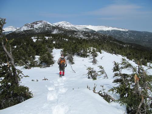
Join us for this 9.6 mile winter hike to the summits of two prominent 4000-foot peaks in the Presidential Range...Mt. Pierce (4312') and Mt. Eisenhower (4760'). We will take the Crawford Path up to the summit of Mt. Pierce with its relatively open summit. From Pierce we will assess if we should continue to Mt. Eisenhower based on weather conditions.
This open summit features incredible 360-degree views. Views from here are spectacular...including views towards Mt. Washington and the surrounding wilderness. Thereafter, we will retrace our steps.
There is approximately 3200 feet in elevation gain. The Crawford Path is among the least aggressive trails to 4000-foot peaks but there are some rough spots close to the summit of Eisenhower. MicroSpikes should be sufficient but if there is a recent snowstorm, we might need snowshoes. Will email the group on the Wednesday before as to the weather status. This trip will take about 8 hours.
The ridge between the two peaks has some low-growing trees/scrub, but it is fairly exposed and continues to open up as we summit Eisenhower, which is totally exposed. This will be a long day with exposure to weather above-tree line in winter. Note this hike is considered strenuous and above tree line exposure can make it extremely hazardous, as such members should have the fitness and gear to match the conditions.
What to wear/bring: MicroSpikes are required but we may need snowshoes if there has been a recent snowstorm. We may not need snowshoes at the start so you should be prepared to strap your snowshoes onto your pack using bungy cords. Wear warm clothing suitable for the exposed ledge and summit(s)...no cotton or blue jeans. You should also have insulated winter boots suitable for the season. Additionally, consider bringing goggles, face protection and a headlamp/flashlight. Bring along plenty of water (at least 2 liters), lunch, snacks and anything else you may require for a winter day hike.
Directions
As you pass the exit for Lincoln, continue on I-93 N for 11.9 miles. Take exit 35 to merge onto US-3 North toward Twin Mountain. Follow US-3 N for 10.3 miles. Turn right onto US-302 and follow US-302 East for 8.4 miles where you'll drive by Bretton Woods Ski Area and the Mt. Washington Hotel. The Crawford Path parking will be on the left... just before the AMC Highlander Center...taking a left for a short distance up the Mt. Clinton Road (beyond this, the road is closed). There might will available street parking and parking at the Highlander Center. Total distance from Lincoln is 30.8 miles (about 35 minutes). Look for a white Honda CRV.
About this event
Join us for this 9.6 mile winter hike to the summits of two prominent 4000-foot peaks in the Presidential Range...Mt. Pierce (4312') and Mt. Eisenhower (4760'). We will take the Crawford Path up to the summit of Mt. Pierce with its relatively open summit. From Pierce we will assess if we should continue to Mt. Eisenhower based on weather conditions.
This open summit features incredible 360-degree views. Views from here are spectacular...including views towards Mt. Washington and the surrounding wilderness. Thereafter, we will retrace our steps.
There is approximately 3200 feet in elevation gain. The Crawford Path is among the least aggressive trails to 4000-foot peaks but there are some rough spots close to the summit of Eisenhower. MicroSpikes should be sufficient but if there is a recent snowstorm, we might need snowshoes. Will email the group on the Wednesday before as to the weather status. This trip will take about 8 hours.
The ridge between the two peaks has some low-growing trees/scrub, but it is fairly exposed and continues to open up as we summit Eisenhower, which is totally exposed. This will be a long day with exposure to weather above-tree line in winter. Note this hike is considered strenuous and above tree line exposure can make it extremely hazardous, as such members should have the fitness and gear to match the conditions.
What to wear/bring: MicroSpikes are required but we may need snowshoes if there has been a recent snowstorm. We may not need snowshoes at the start so you should be prepared to strap your snowshoes onto your pack using bungy cords. Wear warm clothing suitable for the exposed ledge and summit(s)...no cotton or blue jeans. You should also have insulated winter boots suitable for the season. Additionally, consider bringing goggles, face protection and a headlamp/flashlight. Bring along plenty of water (at least 2 liters), lunch, snacks and anything else you may require for a winter day hike.
Directions to the trailhead
Get directionsAs you pass the exit for Lincoln, continue on I-93 N for 11.9 miles. Take exit 35 to merge onto US-3 North toward Twin Mountain. Follow US-3 N for 10.3 miles. Turn right onto US-302 and follow US-302 East for 8.4 miles where you'll drive by Bretton Woods Ski Area and the Mt. Washington Hotel. The Crawford Path parking will be on the left... just before the AMC Highlander Center...taking a left for a short distance up the Mt. Clinton Road (beyond this, the road is closed). There might will available street parking and parking at the Highlander Center. Total distance from Lincoln is 30.8 miles (about 35 minutes). Look for a white Honda CRV.
Who's going (6)



Questions about this event?
Log in to see who's hosting and to ask them questions in the event discussion.
Log in
Event discussion
Log in to join the conversation.