
Purgatory Chasm
Purgatory Chasm
Details
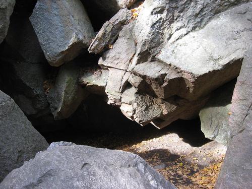
Purgatory Chasm State Reservation is notable for its .25-mile-long (400 m), 70-foot-deep (21 m) chasm of granite bedrock with abrupt precipices and caves. Various theories have been proposed to account for the creation of the chasm. According to one source, it was created when glacial meltwater ripped out bedrock at the end of the last Ice Age.
The park is located at 198 Purgatory Rd. Sutton, MA 01590, off of route 146
Please note that as a state park, MA residents park for $5, non-MA residents pay $20.
MA senior citizens get a lifetime parking pass. Non seniors can get a parking pass for MA state parks.
There is another more interesting story for the formation of the chasm: An Algonquin Indian woman found herself in a tight spot (pun intended) shortly after she killed a white colonial settler. As she walked away from the scene of the crime, she encountered another settler who asked for her company on a short walk. Naturally, having just murdered one of his people, she was apprehensive and tried to run away. He lunged and grabbed her by the wrist. When she called out to the Native American god Hobomoko to save her, the second settler revealed himself as none other than Hobomoko in the flesh. Morphing into a devil-like guise, Hobomoko grabbed his captive by the waist and flew to Purgatory Chasm.
Colonists said that the devil’s actions on that day formed the chasm. The deep depressions were allegedly the places he stomped and threw his victim. The large, deep cuts in the rocks were the results of a swinging tomahawk.
There are 2 miles of trails to sorts of rock formations and breathtaking views of chasm. One suggested hike is the Chasm Loop Trail:
Trailhead: Park at the Visitor Center
Distance: 1 mile loop Difficulty: Moderate
Brief Description: This hike starts across the street from the Visitor Center. Begin on the left hand route and follow the blue blazes. Take side trails to view the Devil's Corncrib and Fat Man's Misery. Continue and return through the center of the Chasm where you will encounter natural rock formations like the Devil’s Pulpit and Lover's Leap
Please consider bringing lunch for the hike. I hope that it would be warm enough to eat outdoors.
Directions
The park is off of Route 146, exit 11 toward Northbridge. You can get to Route 146 from I-190 from the North, I-90 from East or West. Use Route 146 when coming from RI. We will meet at the Visitor Center.
About this event
Purgatory Chasm State Reservation is notable for its .25-mile-long (400 m), 70-foot-deep (21 m) chasm of granite bedrock with abrupt precipices and caves. Various theories have been proposed to account for the creation of the chasm. According to one source, it was created when glacial meltwater ripped out bedrock at the end of the last Ice Age.
The park is located at 198 Purgatory Rd. Sutton, MA 01590, off of route 146
Please note that as a state park, MA residents park for $5, non-MA residents pay $20.
MA senior citizens get a lifetime parking pass. Non seniors can get a parking pass for MA state parks.
There is another more interesting story for the formation of the chasm: An Algonquin Indian woman found herself in a tight spot (pun intended) shortly after she killed a white colonial settler. As she walked away from the scene of the crime, she encountered another settler who asked for her company on a short walk. Naturally, having just murdered one of his people, she was apprehensive and tried to run away. He lunged and grabbed her by the wrist. When she called out to the Native American god Hobomoko to save her, the second settler revealed himself as none other than Hobomoko in the flesh. Morphing into a devil-like guise, Hobomoko grabbed his captive by the waist and flew to Purgatory Chasm.
Colonists said that the devil’s actions on that day formed the chasm. The deep depressions were allegedly the places he stomped and threw his victim. The large, deep cuts in the rocks were the results of a swinging tomahawk.
There are 2 miles of trails to sorts of rock formations and breathtaking views of chasm. One suggested hike is the Chasm Loop Trail:
Trailhead: Park at the Visitor Center
Distance: 1 mile loop Difficulty: Moderate
Brief Description: This hike starts across the street from the Visitor Center. Begin on the left hand route and follow the blue blazes. Take side trails to view the Devil's Corncrib and Fat Man's Misery. Continue and return through the center of the Chasm where you will encounter natural rock formations like the Devil’s Pulpit and Lover's Leap
Please consider bringing lunch for the hike. I hope that it would be warm enough to eat outdoors.
Directions to the trailhead
Get directionsThe park is off of Route 146, exit 11 toward Northbridge. You can get to Route 146 from I-190 from the North, I-90 from East or West. Use Route 146 when coming from RI. We will meet at the Visitor Center.
Who's going (13)
 SUSTAINING
  GUEST MEMBER
  GUEST MEMBER
  GUEST MEMBER
  SUSTAINING
  GUEST MEMBER
  GUEST MEMBER
  SUSTAINING
 Questions about this event?
Reach out to the host, Eli02116, for route details, carpooling, or what to bring.
Email the hostYou can also ask in the event discussion below.
Event discussion
Log in to join the conversation.