
Afternoon Breakheart Reservation Loop - Oct 1
Easy
Details
10/01/2022 2pm Region: New EnglandActivity Type: Hiking/WalkPlace: Wakefield, MA - Just North of Boston.
This will be a 2-2.5 mile 2:00pm loop hike around Pearce Lake (Lower Pond) in the Breakheart Reservation North of Boston. We will be entering at the less well known REAR Hemlock Road entrance on the West side in Wakefield. Entering from the west gets us away from the traffic hum from Route 1.
The last third of the hike will be on a paved roadway. The first 2/3rds can be either on roads or trails or a combination of the two. The trails are closer (or on) the water's edge and will entail the occasional muddy spot and roots to step over. One section is a big flat sloped rocky area. The roads are a bit back without any obstacles. (All the roads are closed to traffic.) We will plan on taking the trails, but please comment if you'd rather take the roads. We'll go with the majority as it is in the comments here on Wednesday night.
The GAIA app is saying it's an ascent of 182'; maximum elevation of 173'; minimum elevation 80'.
Breakheart Reservation info can be found at https://www.mass.gov/locations/breakheart-reservation (it's a Mass DCR property). There's a downloadable trail map that shows the terrain. Entering from the left, the specific trails are the Fern and Pearce Lake trails to the beach. Then the Hemlock road back.
-Chris L
Directions
It's a short drive from both Rte 1 and Rte I-95. Parking is at the
Northeast Metropolitan Regional Technical Vocational High School
100 Hemlock Road
Wakefield, MA 01880
Youll see the reservation entrance at the two stone pillars at the far end of the parking lot. We'll meet to the left of that, between the school and the entrance. I will try and remember to wear my black Yosemite cap (it has a round logo).
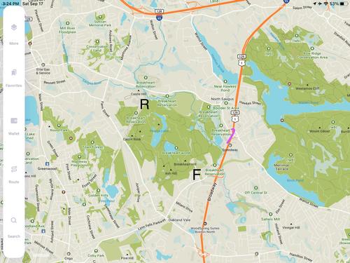
Heres tht Google Maps info. A reminder - we are meeting at the REAR Hemlock Road entrance in Wakefield (the "R" on the attached screenshot, *not* the main entrance (the "F"))
The map should be centered on the Breakheart Res so you can see it and and zoom out to see where it is near Rtes 1 and I-95. entrance is in the upper left.
https://www.google.com/maps/@42.4891846,-71.0309393,13.68z
About this event
10/01/2022 2pm Region: New EnglandActivity Type: Hiking/WalkPlace: Wakefield, MA - Just North of Boston.
This will be a 2-2.5 mile 2:00pm loop hike around Pearce Lake (Lower Pond) in the Breakheart Reservation North of Boston. We will be entering at the less well known REAR Hemlock Road entrance on the West side in Wakefield. Entering from the west gets us away from the traffic hum from Route 1.
The last third of the hike will be on a paved roadway. The first 2/3rds can be either on roads or trails or a combination of the two. The trails are closer (or on) the water's edge and will entail the occasional muddy spot and roots to step over. One section is a big flat sloped rocky area. The roads are a bit back without any obstacles. (All the roads are closed to traffic.) We will plan on taking the trails, but please comment if you'd rather take the roads. We'll go with the majority as it is in the comments here on Wednesday night.
The GAIA app is saying it's an ascent of 182'; maximum elevation of 173'; minimum elevation 80'.
Breakheart Reservation info can be found at https://www.mass.gov/locations/breakheart-reservation (it's a Mass DCR property). There's a downloadable trail map that shows the terrain. Entering from the left, the specific trails are the Fern and Pearce Lake trails to the beach. Then the Hemlock road back.
-Chris L
Directions to the trailhead
Get directions
It's a short drive from both Rte 1 and Rte I-95. Parking is at the
Northeast Metropolitan Regional Technical Vocational High School
100 Hemlock Road
Wakefield, MA 01880
Youll see the reservation entrance at the two stone pillars at the far end of the parking lot. We'll meet to the left of that, between the school and the entrance. I will try and remember to wear my black Yosemite cap (it has a round logo).
Heres tht Google Maps info. A reminder - we are meeting at the REAR Hemlock Road entrance in Wakefield (the "R" on the attached screenshot, *not* the main entrance (the "F"))
The map should be centered on the Breakheart Res so you can see it and and zoom out to see where it is near Rtes 1 and I-95. entrance is in the upper left.
https://www.google.com/maps/@42.4891846,-71.0309393,13.68z
Who's going (3)


Questions about this event?
Log in to see who's hosting and to ask them questions in the event discussion.
Log in
Event discussion
I just wanted to check in about the hike tomorrow. I haven't been paying much attention to the weather and I'm seeing there's a 43% chance of rain. If we want to play it by ear, we could meet at the trail head and do the hike or go for coffee. (I will be down that way anyway.) If you'd rather just cancel let me know.
I'm not sure how the website sends this. Hopefully it'll let you reply.
Log in to join the conversation.