
Sandwich Mountain Fall Foliage Hike
This peak overlooks Waterville Valley, whose fall colors should be on full display at this time!
Sandwich Mountain Fall Foliage Hike
This peak overlooks Waterville Valley, whose fall colors should be on full display at this time!
Details
This peak overlooks Waterville Valley, whose fall colors should be on full display at this time! This peak is on both the New England 100 Highest and 52 with a View lists. We’ll be hiking up the less used Algonquin Trail with few people on a busy Columbus Day Weekend.
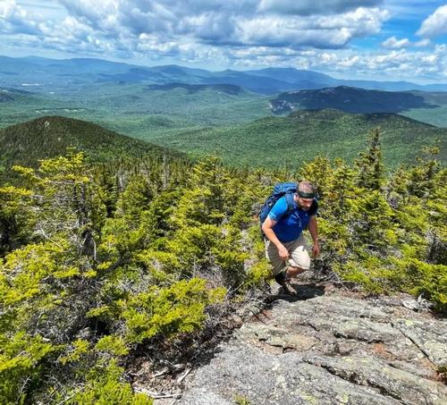
The hike is about 9 miles, 2,850 elevation gain, and provides many extensive views from the open ledges on the southwest shoulder, sometimes called Black Mountain; Sandwich Mountain has fine views north over Waterville Valley. The varied terrain includes a few steep climbs, some technical terrain and one difficult/intimidating rock scramble for those with a fear of heights with a thirty foot drop directly behind it if you slipped.
Don't forget to bring wind/rain shell, water, lunch, snacks, warm hat/gloves, fleece, etc. along with whatever you typically have for a hiking excursion in autumn. We’ll have lunch on top of the summit.
Social Mixer: Following the hike, everyone is welcome back at our house in Waterville Valley, socialize around the deck and/or fireplace and enjoy dinner! It's BYOB and it costs $10 per person.
Lodging Option: Bunk beds are available at our house near Waterville Valley, NH for Friday and Saturday night. Its $25 dollars for Friday night and $25 for Saturday night. Coffee/bagels each morning and linen/blankets/towels are provided. We have 4 bunks available so the first 4 guys that contact us to reserve will get one; and let us know which night[s] you’ll be lodging with us. You’re on your own for dinner Friday night but you’re welcome to use our kitchen facilities to cook!
Directions
Trailhead is on the north side of the narrow, dirt and rough Sandwich Notch Road [low clearance cars may have difficulty], 1.4 miles north of the power line along Beebe River and 3.5 miles south of NH 49. Sandwich Notch Road is off I-93, Exit 28, about 5 miles off NH 49 as you head towards Waterville Valley; if you reached Smarts Brook Trailhead parking you missed the road. We'll be driving a blue Toyota Tacoma.
About this event
This peak overlooks Waterville Valley, whose fall colors should be on full display at this time! This peak is on both the New England 100 Highest and 52 with a View lists. We’ll be hiking up the less used Algonquin Trail with few people on a busy Columbus Day Weekend.
The hike is about 9 miles, 2,850 elevation gain, and provides many extensive views from the open ledges on the southwest shoulder, sometimes called Black Mountain; Sandwich Mountain has fine views north over Waterville Valley. The varied terrain includes a few steep climbs, some technical terrain and one difficult/intimidating rock scramble for those with a fear of heights with a thirty foot drop directly behind it if you slipped.
Don't forget to bring wind/rain shell, water, lunch, snacks, warm hat/gloves, fleece, etc. along with whatever you typically have for a hiking excursion in autumn. We’ll have lunch on top of the summit.
Social Mixer: Following the hike, everyone is welcome back at our house in Waterville Valley, socialize around the deck and/or fireplace and enjoy dinner! It's BYOB and it costs $10 per person.
Lodging Option: Bunk beds are available at our house near Waterville Valley, NH for Friday and Saturday night. Its $25 dollars for Friday night and $25 for Saturday night. Coffee/bagels each morning and linen/blankets/towels are provided. We have 4 bunks available so the first 4 guys that contact us to reserve will get one; and let us know which night[s] you’ll be lodging with us. You’re on your own for dinner Friday night but you’re welcome to use our kitchen facilities to cook!
Directions to the trailhead
Get directionsTrailhead is on the north side of the narrow, dirt and rough Sandwich Notch Road [low clearance cars may have difficulty], 1.4 miles north of the power line along Beebe River and 3.5 miles south of NH 49. Sandwich Notch Road is off I-93, Exit 28, about 5 miles off NH 49 as you head towards Waterville Valley; if you reached Smarts Brook Trailhead parking you missed the road. We'll be driving a blue Toyota Tacoma.
Who's going (8)
 SUSTAINING
  GUEST MEMBER
  SUSTAINING
  GUEST MEMBER
  SUSTAINING
  SUSTAINING
 Questions about this event?
Reach out to the host, Gandalf, for route details, carpooling, or what to bring.
Email the hostYou can also ask in the event discussion below.
Event discussion
If you need a ride, please send an email to me so we don't miss anyone. Thanks.
Log in to join the conversation.