
Mt. Agamenticus Three Hills Hike
This hike is more challenging that the usual up and down to the summit!
Mt. Agamenticus Three Hills Hike
This hike is more challenging that the usual up and down to the summit!
Details
This hike is more challenging that the usual up and down to the summit!
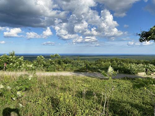
Come for an exhilarating hike at a lower elevation in southern Maine that affords incredible 360 degree views with autumn foliage! On a clear day we can see white capped Mt. Washington on one side and the ocean on the other. Simply amazing! We will explore some of the extensive trails at Mt Agamenticus [691’] that includes three prominent hills. We will hike approximately 6-7 miles.
The trail network consists of rolling terrain with some steep sections with uneven footing. It is expected that participants have been doing some recent hiking and are able to do this mileage. Don't forget to bring wind/rain shell, insulated layers, hat, gloves, water, lunch, snacks, etc. along with whatever you typically have for a hiking excursion in the shoulder season. We’ll have lunch on top of one the hills.
Directions
Directions to Mount A from the South (using Route 1):
Take I-95 North into Maine. Take Exit 7, York (the last exit before the tollbooth for the Maine Turnpike).
Follow signs to Route 1 North (keeping right after the exit ramp). Turn left onto Route 1 North.
Approximately 3.5 miles after turning onto Route 1, turn left on Mountain Road (Across from Flo’s Hotdog Stand). Follow Mountain Road for approximately 4 miles to a stop sign after crossing the interstate. Turn right and continue on Mountain Road for approximately two and a half miles from the interstate overpass. There is a gravel parking lot on the right where we will begin our hike. We are driving a blue Toyota Tacoma Truck.
Directions to Mount Agamenticus from the North:
Take I-95 South to Wells (exit 19).
Turn left from exit onto route 109. Go 1 ½ to 2 miles to route 1.
Turn right (south) onto route 1.
Follow route 1 into Ogunquit and through “downtown.”
At the flashing yellow light hanging over the road, turn right onto Agamenticus Road (turns into Clay Hill Road). Continue about 4 miles (crossing over the Maine Turnpike) to the T-intersection at the end.
Turn right onto Mountain Road and follow it for about 1 mile.
There is a gravel parking lot on the right where we will begin our hike. We are driving a blue Toyota Tacoma Truck.
About this event
This hike is more challenging that the usual up and down to the summit!
Come for an exhilarating hike at a lower elevation in southern Maine that affords incredible 360 degree views with autumn foliage! On a clear day we can see white capped Mt. Washington on one side and the ocean on the other. Simply amazing! We will explore some of the extensive trails at Mt Agamenticus [691’] that includes three prominent hills. We will hike approximately 6-7 miles.
The trail network consists of rolling terrain with some steep sections with uneven footing. It is expected that participants have been doing some recent hiking and are able to do this mileage. Don't forget to bring wind/rain shell, insulated layers, hat, gloves, water, lunch, snacks, etc. along with whatever you typically have for a hiking excursion in the shoulder season. We’ll have lunch on top of one the hills.
Directions to the trailhead
Get directionsDirections to Mount A from the South (using Route 1):
Take I-95 North into Maine. Take Exit 7, York (the last exit before the tollbooth for the Maine Turnpike).
Follow signs to Route 1 North (keeping right after the exit ramp). Turn left onto Route 1 North.
Approximately 3.5 miles after turning onto Route 1, turn left on Mountain Road (Across from Flo’s Hotdog Stand). Follow Mountain Road for approximately 4 miles to a stop sign after crossing the interstate. Turn right and continue on Mountain Road for approximately two and a half miles from the interstate overpass. There is a gravel parking lot on the right where we will begin our hike. We are driving a blue Toyota Tacoma Truck.
Directions to Mount Agamenticus from the North:
Take I-95 South to Wells (exit 19).
Turn left from exit onto route 109. Go 1 ½ to 2 miles to route 1.
Turn right (south) onto route 1.
Follow route 1 into Ogunquit and through “downtown.”
At the flashing yellow light hanging over the road, turn right onto Agamenticus Road (turns into Clay Hill Road). Continue about 4 miles (crossing over the Maine Turnpike) to the T-intersection at the end.
Turn right onto Mountain Road and follow it for about 1 mile.
There is a gravel parking lot on the right where we will begin our hike. We are driving a blue Toyota Tacoma Truck.
Who's going (9)
 SUSTAINING
  SUSTAINING
  GUEST MEMBER
  SUSTAINING
  GUEST MEMBER
  GUEST MEMBER
  SUSTAINING
  GUEST MEMBER
  SUSTAINING
 Waiting list (6)





Questions about this event?
Reach out to the host, Gandalf, for route details, carpooling, or what to bring.
Email the hostYou can also ask in the event discussion below.
Event discussion
No comments yet.
Log in to join the conversation.