
Lye Brook Falls
Now for something completely different
Details
Lye Brook Falls – Manchester VT
- Elevation (highest point) 1588ft
- Distance to highest point 2.6 miles
- Total trip distance 4.4 miles.
This trip is considered MODERATE.
Group will meet at the Lye Falls Trail Head at 10 am and depart by 10:20.
Trail Details and Distances:
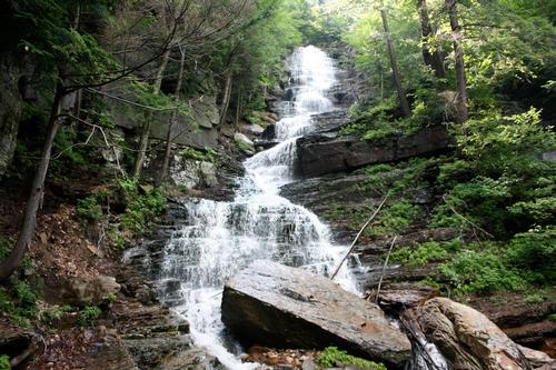
Many requests for new adventures in Vermont. This trail has a moderate 2.5-mile hike into Vermont’s largest waterfall. The trail conditions vary from rocky to smooth following trails and old railroad beds. There are several stream crossings and the areas around the falls are steep and slippery. Swimming options are available.
PREPARATION/WHAT TO BRING: The Green Mountains can and do have unpredictable and extreme weather changes year-round. This trail is covered the entire way.
It is recommended to hikers:
- Bug repellent is recommended. Remember the one thing worse than annoying bugs, people complaining about annoying bugs.
- Helpful hint: Avoid perfumed scents in soaps, bodywash and shampoo. These will attract bugs.
- It is highly recommended to bring a BLISTER KIT (DIY kits online). DO NOT wear brand-new footwear, foot first aid most likely will be necessary.
- If you need suggestions on what to bring, PLEASE ASK!!
For this trip it is important to bring along flexibility, patience, and a sense of humor.
Covid – This is a heavily hiked trail. There will be other hikers.
- Please bring a mask for the use when in close proximity to others.
- Respect people’s space
- There are a variety of mask styles to match the variety of covid opinions. Let’s be safe and respect others. We are not the only people on the trail.
Group Size: It is not fun leaving folks out of trips.
- PLEASE cancel so others may join. If you are on the waiting list, please contact me the days prior to the trip, most likely there is room and if needed this trail will allow us to break the group into smaller groups.
- Decreasing the impact to the environment is always a priority!
- Please plan to “carry in and carry out” all items. It may also be possible to collect other hikers’ debris along the way.
Weather: The weather for this trip will be monitored the week prior. If it is a concern any updates or cancellation information will be posted by the Friday prior by 6pm. If it is a cancellation, it will include a rescheduled date so participants can watch for that opportunity.
For weather details.
- Mt Washington Observatory www.mountwashington.org
- National Weather Service – NOAA www.weather.gov
- Weather www.weather.com
Safety is a priority! Any time a hiker is injured or lost a HUGE team of volunteers is dispatched to aid in the search and rescue efforts.
- No one wants to be injured or put other in harm’s way.
- Always be prepared. Know your limits.
- Any questions feel free to contact me.
After trip social: Social gathering is possible and welcome. Manchester VT is a beautiful community with many options available. Pizza and tail gate gathering, or a sit-down meal could be arranged if folks wish to do so.
Resources used to plan this trip:
- AMC Best Day Hikes in Vermont
- Alltrails.com
- Mount Washington Observatory www.mountwashington.org
- US Forest Service www.usfs.gov
Group will meet at the Lye Falls Trail Head at 10 am and depart by 10:20.
Directions
Group will meet at the Lye Falls Trail Head at 10 am and depart by 10:20.
Where to meet:
Using GPS to get to the trail head is possible, but just in case.
Directions from the “Park and Ride” at Exit 4 on VT route 7
56 Dufresne Pond Rd, Manchester Center, VT 05255
Head southwest on Dufresne Pond Rd toward Depot St
279 ft
Turn right onto Depot St
0.8 mi
Turn left onto Richville Rd
0.4 mi
Turn left onto E Manchester Rd
0.6 mi
Turn right onto Glen Rd
0.1 mi
Continue straight onto Lye Brook Falls Service Rd
0.4 mi
About this event
Lye Brook Falls – Manchester VT
- Elevation (highest point) 1588ft
- Distance to highest point 2.6 miles
- Total trip distance 4.4 miles.
This trip is considered MODERATE.
Group will meet at the Lye Falls Trail Head at 10 am and depart by 10:20.
Trail Details and Distances:
Many requests for new adventures in Vermont. This trail has a moderate 2.5-mile hike into Vermont’s largest waterfall. The trail conditions vary from rocky to smooth following trails and old railroad beds. There are several stream crossings and the areas around the falls are steep and slippery. Swimming options are available.
PREPARATION/WHAT TO BRING: The Green Mountains can and do have unpredictable and extreme weather changes year-round. This trail is covered the entire way.
It is recommended to hikers:
- Bug repellent is recommended. Remember the one thing worse than annoying bugs, people complaining about annoying bugs.
- Helpful hint: Avoid perfumed scents in soaps, bodywash and shampoo. These will attract bugs.
- It is highly recommended to bring a BLISTER KIT (DIY kits online). DO NOT wear brand-new footwear, foot first aid most likely will be necessary.
- If you need suggestions on what to bring, PLEASE ASK!!
For this trip it is important to bring along flexibility, patience, and a sense of humor.
Covid – This is a heavily hiked trail. There will be other hikers.
- Please bring a mask for the use when in close proximity to others.
- Respect people’s space
- There are a variety of mask styles to match the variety of covid opinions. Let’s be safe and respect others. We are not the only people on the trail.
Group Size: It is not fun leaving folks out of trips.
- PLEASE cancel so others may join. If you are on the waiting list, please contact me the days prior to the trip, most likely there is room and if needed this trail will allow us to break the group into smaller groups.
- Decreasing the impact to the environment is always a priority!
- Please plan to “carry in and carry out” all items. It may also be possible to collect other hikers’ debris along the way.
Weather: The weather for this trip will be monitored the week prior. If it is a concern any updates or cancellation information will be posted by the Friday prior by 6pm. If it is a cancellation, it will include a rescheduled date so participants can watch for that opportunity.
For weather details.
- Mt Washington Observatory www.mountwashington.org
- National Weather Service – NOAA www.weather.gov
- Weather www.weather.com
Safety is a priority! Any time a hiker is injured or lost a HUGE team of volunteers is dispatched to aid in the search and rescue efforts.
- No one wants to be injured or put other in harm’s way.
- Always be prepared. Know your limits.
- Any questions feel free to contact me.
After trip social: Social gathering is possible and welcome. Manchester VT is a beautiful community with many options available. Pizza and tail gate gathering, or a sit-down meal could be arranged if folks wish to do so.
Resources used to plan this trip:
- AMC Best Day Hikes in Vermont
- Alltrails.com
- Mount Washington Observatory www.mountwashington.org
- US Forest Service www.usfs.gov
Group will meet at the Lye Falls Trail Head at 10 am and depart by 10:20.
Directions to the trailhead
Get directionsGroup will meet at the Lye Falls Trail Head at 10 am and depart by 10:20.
Where to meet:
Using GPS to get to the trail head is possible, but just in case.
Directions from the “Park and Ride” at Exit 4 on VT route 7
56 Dufresne Pond Rd, Manchester Center, VT 05255
Head southwest on Dufresne Pond Rd toward Depot St
279 ft
Turn right onto Depot St
0.8 mi
Turn left onto Richville Rd
0.4 mi
Turn left onto E Manchester Rd
0.6 mi
Turn right onto Glen Rd
0.1 mi
Continue straight onto Lye Brook Falls Service Rd
0.4 mi
Who's going (5)
 GUEST MEMBER
  GUEST MEMBER
  GUEST MEMBER
  GUEST MEMBER
 Questions about this event?
Reach out to the host, nhclimber03264, for route details, carpooling, or what to bring.
Email the hostYou can also ask in the event discussion below.
Event discussion
Please super hydrate before hiking and carry at least 2 liters of water.
Jon
Log in to join the conversation.