
Get Fit #4: Mt. Shaw
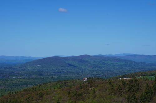
Mt. Shaw offers magnificent views north towards the White Mountains from Castle in the Clouds Conservation Area!
Get Fit #4: Mt. Shaw
Mt. Shaw offers magnificent views north towards the White Mountains from Castle in the Clouds Conservation Area!
Details
Mt. Shaw offers magnificent views north towards the White Mountains from Castle in the Clouds Conservation Area!
Our last GetFit Hike! We will be hiking Mt. Shaw [2,990 feet], the highest of the Ossipee Mountains, affording magnificent views north towards the White Mountains and other mountains to the east from its partly cleared summit and is ascended by a combination of trails from the Castle in the Clouds property. The total distance covered is 7.4 miles, it should take approximately 5-6 hours and the elevation gain is 1,850 feet.
Bring water, lunch, snacks, and rain/wind shell in the event of any inclement weather.
We are keeping the hike at 10 people to make it easier to practice the recommended social distancing of keeping about 6 feet of distance between everyone. Join us for a hike in the great outdoors for some fresh air and some much needed camaraderie!
Hiking Coordinators: Mike Boisvert and Jon Normand
Directions
To reach the mountain, we’ll meet at Ossipee Park Road, just outside the gate to the Castle in the Clouds grounds; Ossipee Park Road leaves NH 171 0.5 mile southeast of its junction with NH 109 and rises steeply for 1.3 miles to the signed parking area on the right. We’ll be driving a blue Toyota Tacoma truck.
About this event
Mt. Shaw offers magnificent views north towards the White Mountains from Castle in the Clouds Conservation Area!
Our last GetFit Hike! We will be hiking Mt. Shaw [2,990 feet], the highest of the Ossipee Mountains, affording magnificent views north towards the White Mountains and other mountains to the east from its partly cleared summit and is ascended by a combination of trails from the Castle in the Clouds property. The total distance covered is 7.4 miles, it should take approximately 5-6 hours and the elevation gain is 1,850 feet.
Bring water, lunch, snacks, and rain/wind shell in the event of any inclement weather.
We are keeping the hike at 10 people to make it easier to practice the recommended social distancing of keeping about 6 feet of distance between everyone. Join us for a hike in the great outdoors for some fresh air and some much needed camaraderie!
Hiking Coordinators: Mike Boisvert and Jon Normand
Directions to the trailhead
Get directionsTo reach the mountain, we’ll meet at Ossipee Park Road, just outside the gate to the Castle in the Clouds grounds; Ossipee Park Road leaves NH 171 0.5 mile southeast of its junction with NH 109 and rises steeply for 1.3 miles to the signed parking area on the right. We’ll be driving a blue Toyota Tacoma truck.
Who's going (8)
 SUSTAINING
  GUEST MEMBER
  SUSTAINING
  SUSTAINING
  GUEST MEMBER
 Questions about this event?
Reach out to the host, Gandalf, for route details, carpooling, or what to bring.
Email the hostYou can also ask in the event discussion below.
Event discussion
No comments yet.
Log in to join the conversation.