
Hike to Mount Israel
5.4 mile hike roundtrip to Mt. Israel via Bearcamp Trail and Wentworth Trail
Hike to Mount Israel
5.4 mile hike roundtrip to Mt. Israel via Bearcamp Trail and Wentworth Trail
Details
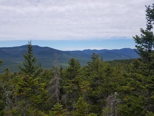
NOTE: The new time to meet for this hike is 10:00. Join us for this moderate hike that begins with the Bearcamp Trail on Sandwich Notch Road. This moderately flat trail of 0.6 mi includes time along the Bearcamp River and a stop at Beede Falls and a view of Cow Cave. At 0.6 mi we join the Wentworth Trail and hike for 2.1 mi through beautiful forest to the peak of Mt Israel. If the clouds cooperate, we should see great views of the Lakes Region along the way and from the peak. We descend by the same trails. The hike is 5.4 miles out and back with 1630 feet of elevation gain. Most of the elevation gain occurs on the Wentworth Trail, with an average grade of 15%.
This hike is limited to 7 people so that we can practice the recommended social distancing and stay at least 6 feet away from each other. Please bring a face covering to use while at the trailhead and when passing other hikers.
We’ll eat lunch at the peak, so bring your lunch. Also bring or wear layers to accommodate late August temperatures. It’s always important to bring at least 1 liter of water, rain gear, sunscreen, and bug spray.
Rain will cancel.
Directions
You can put "Beede Falls" into your GPS, but note that some GPS devices will direct you to go to far along Sandwich Notch Rd. The trailhead is in Sandwich Notch Park on Sandwich Notch Rd, 3.2 miles from Center Sandwich. From intersection of Rt 113 and Grove St, head northwest on Grove St and travel 2.5 miles (road changes name to Diamond Ledge Rd at some point and also becomes gravel road after 1.5 mi). The road then forks, and sign directs you to bear left for Sandwich Notch Rd. Go 0.7 miles. Trailhead parking lot is on right and labeled “Beede Falls.” Please give yourself a little extra time to accommodate travel on gravel roads.
About this event
NOTE: The new time to meet for this hike is 10:00. Join us for this moderate hike that begins with the Bearcamp Trail on Sandwich Notch Road. This moderately flat trail of 0.6 mi includes time along the Bearcamp River and a stop at Beede Falls and a view of Cow Cave. At 0.6 mi we join the Wentworth Trail and hike for 2.1 mi through beautiful forest to the peak of Mt Israel. If the clouds cooperate, we should see great views of the Lakes Region along the way and from the peak. We descend by the same trails. The hike is 5.4 miles out and back with 1630 feet of elevation gain. Most of the elevation gain occurs on the Wentworth Trail, with an average grade of 15%.
This hike is limited to 7 people so that we can practice the recommended social distancing and stay at least 6 feet away from each other. Please bring a face covering to use while at the trailhead and when passing other hikers.
We’ll eat lunch at the peak, so bring your lunch. Also bring or wear layers to accommodate late August temperatures. It’s always important to bring at least 1 liter of water, rain gear, sunscreen, and bug spray.
Rain will cancel.
Directions to the trailhead
Get directionsYou can put "Beede Falls" into your GPS, but note that some GPS devices will direct you to go to far along Sandwich Notch Rd. The trailhead is in Sandwich Notch Park on Sandwich Notch Rd, 3.2 miles from Center Sandwich. From intersection of Rt 113 and Grove St, head northwest on Grove St and travel 2.5 miles (road changes name to Diamond Ledge Rd at some point and also becomes gravel road after 1.5 mi). The road then forks, and sign directs you to bear left for Sandwich Notch Rd. Go 0.7 miles. Trailhead parking lot is on right and labeled “Beede Falls.” Please give yourself a little extra time to accommodate travel on gravel roads.
Who's going (4)
 SUSTAINING
  GUEST MEMBER
  SUSTAINING
 Questions about this event?
Reach out to the host, jkelaghan, for route details, carpooling, or what to bring.
Email the hostYou can also ask in the event discussion below.
Event discussion
No comments yet.
Log in to join the conversation.